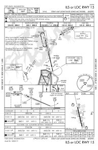
IAC chart of KGRF
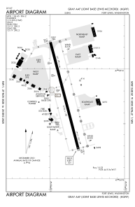
 ADC chart of KGRF
 Satellite view of KGRF

ADC chart of KGRF
Satellite view of KGRF
Sorry, we have no imagery here.
Sorry, we have no imagery here.
Sorry, we have no imagery here.
Sorry, we have no imagery here.
Sorry, we have no imagery here.
Sorry, we have no imagery here.


KGRF - Gray Aaf (Joint Base Lewis-Mcchord)
Located in Fort Lewis/Tacoma, United States
ICAO - GRF, IATA - GRF
Data provided by AirmateGeneral information
Coordinates: N47°4'45" W122°34'51"
Elevation is 301 feet MSL.
Magnetic variation is 16° East View others Airports in Washington
Operational data
Special qualification required
Current time UTC: 10:19:13
Current local time:
Weather
METAR: KGRF 290955Z AUTO 12005KT 10SM BKN170 12/09 A3002 RMK AO2 SLP168 T01150094 $
TAF: TAF KGRF 290500Z 2905/3011 25010G20KT 9999 SKC QNH2999INS BECMG 2908/2909 22008KT 9999 BKN018 BKN080 QNH3004INS BECMG 2912/2913 17004KT 9999 -RA OVC025 QNH3005INS BECMG 2913/2914 18004KT 8000 -RA BR SCT008 BKN010 OVC020 QNH3006INS BECMG 2917/2918 19010G15KT 9999 -SHRA BKN015 BKN020 QNH3009INS BECMG 2921/2922 22010G18KT 9999 NSW FEW040 QNH3019INS BECMG 3007/3008 23010KT 9999 SKC QNH3025INS TX19/2923Z TN12/2914Z
Communications frequencies: [VIEW]
Runways:
| RWY identifier | QFU | Length (ft) | Width (ft) | Surface | LDA (ft) |
| 15 | 167° | 6124 | 150 | ASPH | |
| 33 | 347° | 6124 | 150 | ASPH | |
| H2 | 0° | 0 | 0 | UNK | |
| H3 | 0° | 0 | 0 | UNK | |
| H4 | 0° | 0 | 0 | UNK |
Airport contact information
Address: Fort Lewis/Tacoma United States
Satellite view of KGRF
Sorry, we have no imagery here.
Sorry, we have no imagery here.
Sorry, we have no imagery here.
Sorry, we have no imagery here.
Sorry, we have no imagery here.
Sorry, we have no imagery here.