ADC chart of KGAB
 Satellite view of KGAB
Satellite view of KGAB
Sorry, we have no imagery here.
Sorry, we have no imagery here.
Sorry, we have no imagery here.
Sorry, we have no imagery here.
Sorry, we have no imagery here.
Sorry, we have no imagery here.


KGAB - Gabbs
Located in Gabbs, United States
ICAO - GAB, IATA -
Data provided by AirmateGeneral information
Coordinates: N38°55'20" W117°57'31"
Elevation is 4699 feet MSL.
Magnetic variation is 15° East View others Airports in Nevada
Operational data
Special qualification required
Current time UTC: 10:00:13
Current local time:
Weather at : KHTH - Hawthorne Industrial ( 72 km )
METAR: KHTH 300935Z AUTO 26005KT 10SM CLR 22/M00 A3015 RMK A01
Communications frequencies: [VIEW]
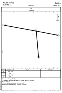
Runways:
| RWY identifier | QFU | Length (ft) | Width (ft) | Surface | LDA (ft) |
| 09 | 101° | 5950 | 65 | EARTH | |
| 27 | 281° | 5950 | 65 | EARTH | |
| 16 | 175° | 2650 | 75 | EARTH | |
| 34 | 355° | 2650 | 75 | EARTH |
Airport contact information
Address: Gabbs United States
Satellite view of KGAB
Sorry, we have no imagery here.
Sorry, we have no imagery here.
Sorry, we have no imagery here.
Sorry, we have no imagery here.
Sorry, we have no imagery here.
Sorry, we have no imagery here.