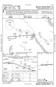
IAC chart of KFYJ
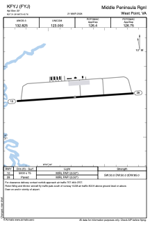
 ADC chart of KFYJ
 Satellite view of KFYJ

ADC chart of KFYJ
Satellite view of KFYJ
Sorry, we have no imagery here.
Sorry, we have no imagery here.
Sorry, we have no imagery here.
Sorry, we have no imagery here.
Sorry, we have no imagery here.
Sorry, we have no imagery here.


KFYJ - Middle Peninsula Rgnl
Located in West Point, United States
ICAO - FYJ, IATA -
Data provided by AirmateGeneral information
Coordinates: N37°31'17" W76°45'46"
Elevation is 20 feet MSL.
Magnetic variation is -11° East View others Airports in Virginia
Operational data
Special qualification required
Current time UTC: 19:08:01
Current local time:
Weather
METAR: KFYJ 301855Z AUTO 13008KT 090V160 10SM CLR 24/19 A2968 RMK AO1 T02440191
Communications frequencies: [VIEW]
Runways:
| RWY identifier | QFU | Length (ft) | Width (ft) | Surface | LDA (ft) |
| 10 | 86° | 5000 | 75 | ASPH | |
| 28 | 266° | 5000 | 75 | ASPH |
Airport contact information
Address: West Point United States
Satellite view of KFYJ
Sorry, we have no imagery here.
Sorry, we have no imagery here.
Sorry, we have no imagery here.
Sorry, we have no imagery here.
Sorry, we have no imagery here.
Sorry, we have no imagery here.