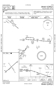
IAC chart of KFLX
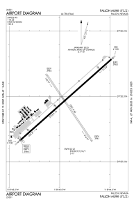
 ADC chart of KFLX
 Satellite view of KFLX

ADC chart of KFLX
Satellite view of KFLX
Sorry, we have no imagery here.
Sorry, we have no imagery here.
Sorry, we have no imagery here.
Sorry, we have no imagery here.
Sorry, we have no imagery here.
Sorry, we have no imagery here.


KFLX - Fallon Muni
Located in Fallon, United States
ICAO - FLX, IATA - FLX
Data provided by AirmateGeneral information
Coordinates: N39°29'57" W118°44'56"
Elevation is 3966 feet MSL.
Magnetic variation is 14° East View others Airports in Nevada
Operational data
Special qualification required
Current time UTC: 13:53:58
Current local time:
Weather at : KNFL - Fallon Nas (Van Voorhis Fld) ( 10 km )
TAF: TAF KNFL 3007/3107 VRB06KT 9999 SKC QNH3006INS FM301700 33006KT 9999 FEW200 QNH3001INS AUTOMATED SENSOR METWATCH 3007 TIL 3014 TX34/3023Z TN13/3013Z FS30236
Communications frequencies: [VIEW]
Runways:
| RWY identifier | QFU | Length (ft) | Width (ft) | Surface | LDA (ft) |
| 03 | 48° | 5705 | 75 | ASPH | |
| 21 | 228° | 5705 | 75 | ASPH | |
| 13 | 146° | 3581 | 60 | EARTH | |
| 31 | 326° | 3581 | 60 | EARTH |
Airport contact information
Address: Fallon United States
Satellite view of KFLX
Sorry, we have no imagery here.
Sorry, we have no imagery here.
Sorry, we have no imagery here.
Sorry, we have no imagery here.
Sorry, we have no imagery here.
Sorry, we have no imagery here.