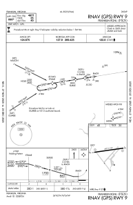
IAC chart of KFKN
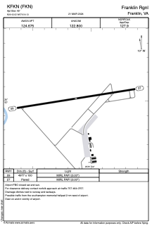
 ADC chart of KFKN
 Satellite view of KFKN
ADC chart of KFKN
Satellite view of KFKN
Sorry, we have no imagery here.
Sorry, we have no imagery here.
Sorry, we have no imagery here.
Sorry, we have no imagery here.
Sorry, we have no imagery here.
Sorry, we have no imagery here.


KFKN - Franklin Rgnl
Located in Franklin, United States
ICAO - FKN, IATA - FKN
Data provided by AirmateGeneral information
Coordinates: N36°42'1" W76°54'8"
Elevation is 40 feet MSL.
Magnetic variation is -09° East View others Airports in Virginia
Operational data
Special qualification required
Current time UTC: 18:10:34
Current local time:
Weather
METAR: KFKN 301755Z AUTO 23009KT 10SM BKN032 BKN050 BKN060 26/18 A2969 RMK AO2 T02590179 10260 20202
Communications frequencies: [VIEW]
Runways:
| RWY identifier | QFU | Length (ft) | Width (ft) | Surface | LDA (ft) |
| 09 | 81° | 4977 | 100 | ASPH | |
| 27 | 261° | 4977 | 100 | ASPH |
Airport contact information
Address: Franklin United States
Satellite view of KFKN
Sorry, we have no imagery here.
Sorry, we have no imagery here.
Sorry, we have no imagery here.
Sorry, we have no imagery here.
Sorry, we have no imagery here.
Sorry, we have no imagery here.