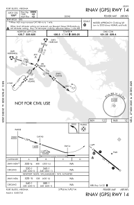
IAC chart of KFAF
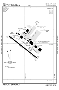
 ADC chart of KFAF
 Satellite view of KFAF
ADC chart of KFAF
Satellite view of KFAF
Sorry, we have no imagery here.
Sorry, we have no imagery here.
Sorry, we have no imagery here.
Sorry, we have no imagery here.
Sorry, we have no imagery here.
Sorry, we have no imagery here.


KFAF - Felker Aaf
Located in Fort Eustis, United States
ICAO - FAF, IATA - FAF
Data provided by AirmateGeneral information
Coordinates: N37°7'57" W76°36'32"
Elevation is 11 feet MSL.
Magnetic variation is -11° East View others Airports in Virginia
Operational data
Special qualification required
Current time UTC: 15:10:14
Current local time:
Weather
METAR: KFAF 291455Z AUTO 33003KT 10SM CLR 19/16 A3006 RMK AO2 SLP183 T01940156 58002 $
TAF: TAF KFAF 291000Z 2910/3016 32009KT 9999 OVC007 QNH3007INS BECMG 2911/2912 24009KT 9999 FEW010 BKN020 OVC025 QNH3004INS BECMG 2918/2919 20012KT 8000 -DZ BKN020 OVC025 QNH3003INS BECMG 2920/2921 23012 9999 NSW OVC020 QNH2995INS BECMG 3004/3005 22012KT 8000 -RA BKN010 OVC020 QNH2991INS BECMG 3010/3011 24006KT 6000 RA BKN007 OVC010 QNH2982INS BECMG 3013/3014 22012KT 9999 NSW BKN010 OVC020 QNH2979INS TX23/2921Z TN14/2910Z
Communications frequencies: [VIEW]
Runways:
| RWY identifier | QFU | Length (ft) | Width (ft) | Surface | LDA (ft) |
| 14 | 128° | 3025 | 75 | ASPH | |
| 32 | 308° | 3025 | 75 | ASPH | |
| H1 | 0° | 0 | 0 | UNK |
Airport contact information
Address: Fort Eustis United States
Satellite view of KFAF
Sorry, we have no imagery here.
Sorry, we have no imagery here.
Sorry, we have no imagery here.
Sorry, we have no imagery here.
Sorry, we have no imagery here.
Sorry, we have no imagery here.