ADC chart of KESW
 Satellite view of KESW

Satellite view of KESW
Sorry, we have no imagery here.
Sorry, we have no imagery here.
Sorry, we have no imagery here.
Sorry, we have no imagery here.
Sorry, we have no imagery here.
Sorry, we have no imagery here.


KESW - Easton State
Located in Easton, United States
ICAO - ESW, IATA - ESW
Data provided by AirmateGeneral information
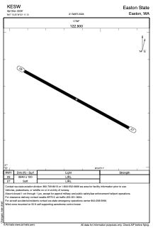
Coordinates: N47°15'15" W121°11'8"
Elevation is 2226 feet MSL.
Magnetic variation is 20° East View others Airports in Washington
Operational data
Special qualification required
Current time UTC: 06:55:06
Current local time:
Weather at : KELN - Bowers Fld ( 55 km )
METAR: KELN 290553Z AUTO 32011KT 10SM CLR 22/11 A2985 RMK AO2 SLP094 T02220106 10322 20211 51009
Communications frequencies: [VIEW]
Runways:
| RWY identifier | QFU | Length (ft) | Width (ft) | Surface | LDA (ft) |
| 09 | 118° | 2640 | 100 | GRASS | |
| 27 | 298° | 2640 | 100 | GRASS |
Airport contact information
Address: Easton United States
Satellite view of KESW
Sorry, we have no imagery here.
Sorry, we have no imagery here.
Sorry, we have no imagery here.
Sorry, we have no imagery here.
Sorry, we have no imagery here.
Sorry, we have no imagery here.