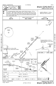
IAC chart of KEPH
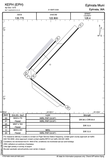
 ADC chart of KEPH
 Satellite view of KEPH

ADC chart of KEPH
Satellite view of KEPH
Sorry, we have no imagery here.
Sorry, we have no imagery here.
Sorry, we have no imagery here.
Sorry, we have no imagery here.
Sorry, we have no imagery here.
Sorry, we have no imagery here.


KEPH - Ephrata Muni
Located in Ephrata, United States
ICAO - EPH, IATA - EPH
Data provided by AirmateGeneral information
Coordinates: N47°18'29" W119°31'1"
Elevation is 1276 feet MSL.
Magnetic variation is 16° East View others Airports in Washington
Operational data
Special qualification required
Current time UTC: 17:58:12
Current local time:
Weather
METAR: KEPH 241753Z AUTO 10SM CLR 22/04 A3004 RMK AO2 SLP167 T02220039 10222 20089 58007
Communications frequencies: [VIEW]
Runways:
| RWY identifier | QFU | Length (ft) | Width (ft) | Surface | LDA (ft) |
| 03 | 43° | 5500 | 75 | ASPH | |
| 21 | 223° | 5500 | 75 | ASPH | |
| 04 | 42° | 3467 | 150 | ASPH | |
| 22 | 222° | 3467 | 150 | ASPH | |
| 11 | 128° | 3843 | 60 | ASPH | |
| 29 | 308° | 3843 | 60 | ASPH |
Airport contact information
Address: Ephrata United States
Satellite view of KEPH
Sorry, we have no imagery here.
Sorry, we have no imagery here.
Sorry, we have no imagery here.
Sorry, we have no imagery here.
Sorry, we have no imagery here.
Sorry, we have no imagery here.