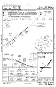
IAC chart of KELM
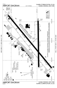
 ADC chart of KELM
 Satellite view of KELM

ADC chart of KELM
Satellite view of KELM
Sorry, we have no imagery here.
Sorry, we have no imagery here.
Sorry, we have no imagery here.
Sorry, we have no imagery here.
Sorry, we have no imagery here.
Sorry, we have no imagery here.


KELM - Elmira/Corning Rgnl
Located in Elmira/Corning, United States
ICAO - ELM, IATA - ELM
Data provided by AirmateGeneral information
Coordinates: N42°9'35" W76°53'30"
Elevation is 955 feet MSL.
Magnetic variation is -12° East View others Airports in New York
Operational data
Special qualification required
Current time UTC: 07:53:24
Current local time:
Weather
METAR: KELM 300750Z AUTO 00000KT 2SM R24/6000VP6000FT BR FEW075 11/11 A2981 RMK AO2
TAF: KELM 300535Z 3006/3106 24003KT P6SM BKN060 FM301500 27007KT P6SM SCT100 BKN250 FM310100 28002KT 6SM -RA BR OVC100
Communications frequencies: [VIEW]
Runways:
| RWY identifier | QFU | Length (ft) | Width (ft) | Surface | LDA (ft) |
| 05 | 50° | 2016 | 150 | GRASS | 2017 |
| 23 | 230° | 2016 | 150 | GRASS | 2017 |
| 06 | 50° | 8001 | 150 | ASPH | 7401 |
| 24 | 230° | 8001 | 150 | ASPH | 7799 |
| 10 | 89° | 5404 | 150 | ASPH | 5004 |
| 28 | 269° | 5404 | 150 | ASPH | 5002 |
Airport contact information
Address: Elmira/Corning United States
Satellite view of KELM
Sorry, we have no imagery here.
Sorry, we have no imagery here.
Sorry, we have no imagery here.
Sorry, we have no imagery here.
Sorry, we have no imagery here.
Sorry, we have no imagery here.