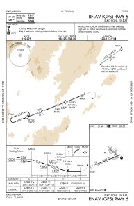
IAC chart of KEKO
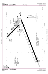
 ADC chart of KEKO
 Satellite view of KEKO

ADC chart of KEKO
Satellite view of KEKO
Sorry, we have no imagery here.
Sorry, we have no imagery here.
Sorry, we have no imagery here.
Sorry, we have no imagery here.
Sorry, we have no imagery here.
Sorry, we have no imagery here.


KEKO - Elko Rgnl
Located in Elko, United States
ICAO - EKO, IATA - EKO
Data provided by AirmateGeneral information
Coordinates: N40°49'30" W115°47'29"
Elevation is 5139 feet MSL.
Magnetic variation is 12° East View others Airports in Nevada
Operational data
Special qualification required
Current time UTC: 13:14:11
Current local time:
Weather
METAR: KEKO 301256Z AUTO 00000KT 10SM CLR 12/04 A3028 RMK AO2 SLP199 T01220039
TAF: KEKO 301134Z 3012/3112 VRB05KT P6SM SKC FM302000 26008G18KT P6SM SKC FM310300 VRB05KT P6SM SKC
Communications frequencies: [VIEW]
Runways:
| RWY identifier | QFU | Length (ft) | Width (ft) | Surface | LDA (ft) |
| 06 | 69° | 7454 | 150 | ASPH | 7217 |
| 24 | 249° | 7454 | 150 | ASPH | 6418 |
| 12 | 134° | 3015 | 60 | ASPH | 2109 |
| 30 | 314° | 3015 | 60 | ASPH | 2872 |
Airport contact information
Address: Elko United States
Other aviation service providers
Flight schools

Mountain West Aviation / El Aero Services
Mountain West Aviation / El Aero Services
elaero1@frontiernet.net7757387123