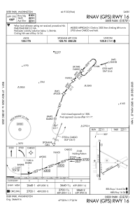
IAC chart of KDEW
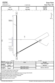
 ADC chart of KDEW
 Satellite view of KDEW

ADC chart of KDEW
Satellite view of KDEW
Sorry, we have no imagery here.
Sorry, we have no imagery here.
Sorry, we have no imagery here.
Sorry, we have no imagery here.
Sorry, we have no imagery here.
Sorry, we have no imagery here.


KDEW - Deer Park
Located in Deer Park, United States
ICAO - DEW, IATA -
Data provided by AirmateGeneral information
Coordinates: N47°58'1" W117°25'43"
Elevation is 2210 feet MSL.
Magnetic variation is 16° East View others Airports in Washington
Operational data
Special qualification required
Current time UTC: 12:54:42
Current local time:
Weather
METAR: KDEW 281153Z AUTO 02009KT 10SM CLR 12/08 A3005 RMK AO2 SLP166 T01220078 10122 20083 58006
Communications frequencies: [VIEW]
Runways:
| RWY identifier | QFU | Length (ft) | Width (ft) | Surface | LDA (ft) |
| 05 | 61° | 3200 | 60 | ASPH | |
| 23 | 241° | 3200 | 60 | ASPH | |
| 16 | 180° | 6101 | 75 | ASPH | |
| 34 | 360° | 6101 | 75 | ASPH |
Airport contact information
Address: Deer Park United States
Satellite view of KDEW
Sorry, we have no imagery here.
Sorry, we have no imagery here.
Sorry, we have no imagery here.
Sorry, we have no imagery here.
Sorry, we have no imagery here.
Sorry, we have no imagery here.