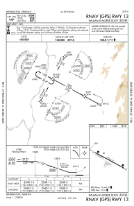
IAC chart of KDDH
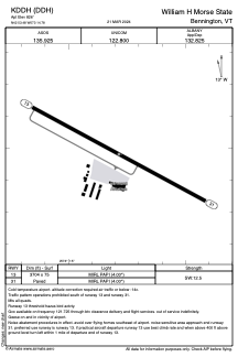
 ADC chart of KDDH
 Satellite view of KDDH

ADC chart of KDDH
Satellite view of KDDH
Sorry, we have no imagery here.
Sorry, we have no imagery here.
Sorry, we have no imagery here.
Sorry, we have no imagery here.
Sorry, we have no imagery here.
Sorry, we have no imagery here.


KDDH - William H Morse State
Located in Bennington, United States
ICAO - DDH, IATA -
Data provided by AirmateGeneral information
Coordinates: N42°53'29" W73°14'47"
Elevation is 826 feet MSL.
Magnetic variation is -14° East View others Airports in Vermont
Operational data
Special qualification required
Current time UTC: 06:23:10
Current local time:
Weather
METAR: KDDH 230554Z AUTO 00000KT 10SM OVC026 05/04 A2978 RMK AO2 SLP089 60011 T00500039 10061 20050 58017
Communications frequencies: [VIEW]
Runways:
| RWY identifier | QFU | Length (ft) | Width (ft) | Surface | LDA (ft) |
| 13 | 118° | 3704 | 75 | ASPH | |
| 31 | 298° | 3704 | 75 | ASPH |
Airport contact information
Address: Bennington United States
Satellite view of KDDH
Sorry, we have no imagery here.
Sorry, we have no imagery here.
Sorry, we have no imagery here.
Sorry, we have no imagery here.
Sorry, we have no imagery here.
Sorry, we have no imagery here.