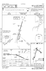
IAC chart of KDAN
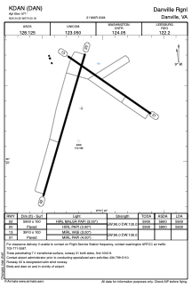
 ADC chart of KDAN
 Satellite view of KDAN

ADC chart of KDAN
Satellite view of KDAN
Sorry, we have no imagery here.
Sorry, we have no imagery here.
Sorry, we have no imagery here.
Sorry, we have no imagery here.
Sorry, we have no imagery here.
Sorry, we have no imagery here.


KDAN - Danville Rgnl
Located in Danville, United States
ICAO - DAN, IATA - DAN
Data provided by AirmateGeneral information
Coordinates: N36°34'21" W79°20'11"
Elevation is 571 feet MSL.
Magnetic variation is -09° East View others Airports in Virginia
Operational data
Special qualification required
Current time UTC: 14:22:33
Current local time:
Weather
METAR: KDAN 301414Z AUTO 23005KT 10SM SCT012 22/18 A2979 RMK AO2 T02170183
TAF: KDAN 301405Z 3014/3112 23005KT P6SM OVC012 FM301500 24006KT P6SM SCT035 BKN060 FM302100 24008KT 3SM TSRA SCT025CB OVC050 FM310000 26010G19KT P6SM SCT060 BKN100 FM310900 26008KT P6SM SCT100
Communications frequencies: [VIEW]
Runways:
| RWY identifier | QFU | Length (ft) | Width (ft) | Surface | LDA (ft) |
| 02 | 16° | 5900 | 100 | ASPH | 5600 |
| 20 | 196° | 5900 | 100 | ASPH | 5600 |
| 13 | 125° | 3910 | 100 | ASPH | |
| 31 | 305° | 3910 | 100 | ASPH |
Airport contact information
Address: Danville United States
