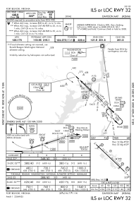
IAC chart of KDAA
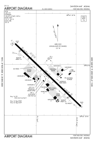
 ADC chart of KDAA
 Satellite view of KDAA

ADC chart of KDAA
Satellite view of KDAA
Sorry, we have no imagery here.
Sorry, we have no imagery here.
Sorry, we have no imagery here.
Sorry, we have no imagery here.
Sorry, we have no imagery here.
Sorry, we have no imagery here.


KDAA - Davison Aaf
Located in Fort Belvoir, United States
ICAO - DAA, IATA - DAA
Data provided by AirmateGeneral information
Coordinates: N38°42'54" W77°10'51"
Elevation is 73 feet MSL.
Magnetic variation is -09° East View others Airports in Virginia
Operational data
Special qualification required
Current time UTC: 09:22:10
Current local time:
Weather
METAR: KDAA 290905Z AUTO 00000KT 10SM OVC008 15/14 A3006 RMK AO2 CIG 008V010 SLP182 $
Communications frequencies: [VIEW]
Runways:
| RWY identifier | QFU | Length (ft) | Width (ft) | Surface | LDA (ft) |
| 14 | 133° | 5421 | 75 | ASPH | |
| 32 | 313° | 5421 | 75 | ASPH | |
| H1 | 0° | 0 | 0 | UNK |
Airport contact information
Address: Fort Belvoir United States
Satellite view of KDAA
Sorry, we have no imagery here.
Sorry, we have no imagery here.
Sorry, we have no imagery here.
Sorry, we have no imagery here.
Sorry, we have no imagery here.
Sorry, we have no imagery here.