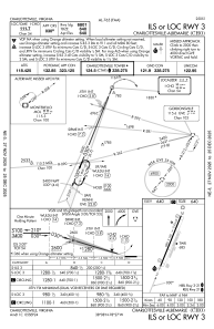
IAC chart of KCHO
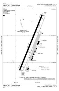
 ADC chart of KCHO
 Satellite view of KCHO

ADC chart of KCHO
Satellite view of KCHO
Sorry, we have no imagery here.
Sorry, we have no imagery here.
Sorry, we have no imagery here.
Sorry, we have no imagery here.
Sorry, we have no imagery here.
Sorry, we have no imagery here.


KCHO - Charlottesville-Albemarle
Located in Charlottesville, United States
ICAO - CHO, IATA - CHO
Data provided by AirmateGeneral information
Coordinates: N38°8'23" W78°27'8"
Elevation is 640 feet MSL.
Magnetic variation is -08° East View others Airports in Virginia
Operational data
Special qualification required
Current time UTC: 03:43:06
Current local time:
Weather
METAR: KCHO 300339Z AUTO 00000KT 10SM FEW009 BKN013 BKN032 19/18 A2992 RMK AO2 RAE15 P0001 T01940183
TAF: KCHO 292339Z 3000/3024 14005KT 6SM -SHRA VCTS OVC035CB FM300600 00000KT P6SM OVC018 FM300800 00000KT 2SM BR SCT002 BKN014 FM301300 00000KT P6SM BKN015 FM301500 16004KT P6SM BKN035
Communications frequencies: [VIEW]
Runways:
| RWY identifier | QFU | Length (ft) | Width (ft) | Surface | LDA (ft) |
| 03 | 22° | 6801 | 150 | ASPH | 6801 |
| 21 | 202° | 6801 | 150 | ASPH | 6801 |
Airport contact information
Address: Charlottesville United States
