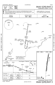
IAC chart of KCDA
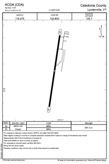
 ADC chart of KCDA
 Satellite view of KCDA

ADC chart of KCDA
Satellite view of KCDA
Sorry, we have no imagery here.
Sorry, we have no imagery here.
Sorry, we have no imagery here.
Sorry, we have no imagery here.
Sorry, we have no imagery here.
Sorry, we have no imagery here.


KCDA - Caledonia County
Located in Lyndonville, United States
ICAO - CDA, IATA - LLX
Data provided by AirmateGeneral information
Coordinates: N44°34'9" W72°1'5"
Elevation is 1187 feet MSL.
Magnetic variation is -16° East View others Airports in Vermont
Operational data
Special qualification required
Current time UTC: 11:19:56
Current local time:
Weather
METAR: KCDA 221115Z AUTO 06009KT 10SM SCT040 SCT046 OVC090 07/03 A3000 RMK AO2 T00670027
Communications frequencies: [VIEW]
Runways:
| RWY identifier | QFU | Length (ft) | Width (ft) | Surface | LDA (ft) |
| 02 | 8° | 3302 | 60 | ASPH | |
| 20 | 188° | 3302 | 60 | ASPH |
Airport contact information
Address: Lyndonville United States
Satellite view of KCDA
Sorry, we have no imagery here.
Sorry, we have no imagery here.
Sorry, we have no imagery here.
Sorry, we have no imagery here.
Sorry, we have no imagery here.
Sorry, we have no imagery here.