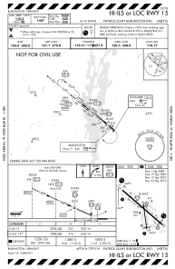
IAC chart of KBTV
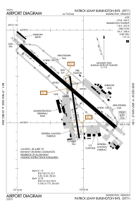
 ADC chart of KBTV
 Satellite view of KBTV
ADC chart of KBTV
Satellite view of KBTV
Sorry, we have no imagery here.
Sorry, we have no imagery here.
Sorry, we have no imagery here.
Sorry, we have no imagery here.
Sorry, we have no imagery here.
Sorry, we have no imagery here.


KBTV - Patrick Leahy Burlington Intl
Located in Burlington, United States
ICAO - BTV, IATA - BTV
Data provided by AirmateGeneral information
Coordinates: N44°28'19" W73°9'12"
Elevation is 334 feet MSL.
Magnetic variation is -15° East View others Airports in Vermont
Operational data
Special qualification required
Current time UTC: 15:25:54
Current local time:
Weather
METAR: KBTV 231454Z 03003KT 10SM BKN016 OVC023 10/06 A2976 RMK AO2 RAE52 SLP078 P0000 60002 T01000056 56006
TAF: KBTV 231439Z 2315/2412 VRB04KT P6SM -RA BKN012 OVC050 FM231600 33005KT P6SM -SHRA BKN015 OVC035 FM240300 00000KT P6SM OVC018 FM240600 32004KT P6SM -SHRA OVC009
Communications frequencies: [VIEW]
Runways:
| RWY identifier | QFU | Length (ft) | Width (ft) | Surface | LDA (ft) |
| 01 | 351° | 4112 | 75 | ASPH | 3386 |
| 19 | 171° | 4112 | 75 | ASPH | 3386 |
| 15 | 131° | 8319 | 150 | OTHER | 7820 |
| 33 | 311° | 8319 | 150 | OTHER | 7820 |
Airport contact information
Address: Burlington United States
