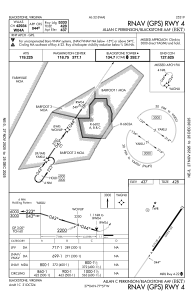
IAC chart of KBKT
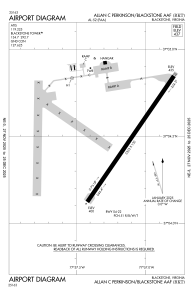
 ADC chart of KBKT
 Satellite view of KBKT
ADC chart of KBKT
Satellite view of KBKT
Sorry, we have no imagery here.
Sorry, we have no imagery here.
Sorry, we have no imagery here.
Sorry, we have no imagery here.
Sorry, we have no imagery here.
Sorry, we have no imagery here.


KBKT - Allan C Perkinson/Blackstone Aaf
Located in Blackstone, United States
ICAO - BKT, IATA - BKT
Data provided by AirmateGeneral information
Coordinates: N37°4'29" W77°57'7"
Elevation is 437 feet MSL.
Magnetic variation is -09° East View others Airports in Virginia
Operational data
Special qualification required
Current time UTC: 19:56:47
Current local time:
Weather
METAR: KBKT 201855Z AUTO 23004KT 10SM FEW320 24/12 A2994 RMK AO2 SLP140 T02370117
Communications frequencies: [VIEW]
Runways:
| RWY identifier | QFU | Length (ft) | Width (ft) | Surface | LDA (ft) |
| 04 | 35° | 5333 | 150 | CONC | |
| 22 | 215° | 5333 | 150 | CONC |
Airport contact information
Address: Blackstone United States
Satellite view of KBKT
Sorry, we have no imagery here.
Sorry, we have no imagery here.
Sorry, we have no imagery here.
Sorry, we have no imagery here.
Sorry, we have no imagery here.
Sorry, we have no imagery here.