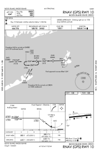
IAC chart of KBID
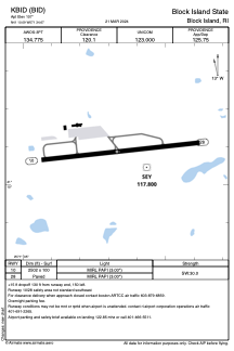
 ADC chart of KBID
 Satellite view of KBID

ADC chart of KBID
Satellite view of KBID
Sorry, we have no imagery here.
Sorry, we have no imagery here.
Sorry, we have no imagery here.
Sorry, we have no imagery here.
Sorry, we have no imagery here.
Sorry, we have no imagery here.


KBID - Block Island State
Located in Block Island, United States
ICAO - BID, IATA - BID
Data provided by AirmateGeneral information
Coordinates: N41°10'5" W71°34'40"
Elevation is 107 feet MSL.
Magnetic variation is -15° East View others Airports in Rhode Island
Operational data
Special qualification required
Current time UTC: 08:33:20
Current local time:
Weather
METAR: KBID 200756Z AUTO 33006KT 10SM CLR M07/M12 A3005 RMK AO2 SLP178 T10721117 FZRANO $
Communications frequencies: [VIEW]
Runways:
| RWY identifier | QFU | Length (ft) | Width (ft) | Surface | LDA (ft) |
| 10 | 84° | 2502 | 100 | ASPH | |
| 28 | 264° | 2502 | 100 | ASPH |
Airport contact information
Address: Block Island United States
Satellite view of KBID
Sorry, we have no imagery here.
Sorry, we have no imagery here.
Sorry, we have no imagery here.
Sorry, we have no imagery here.
Sorry, we have no imagery here.
Sorry, we have no imagery here.