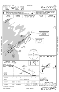
IAC chart of KART
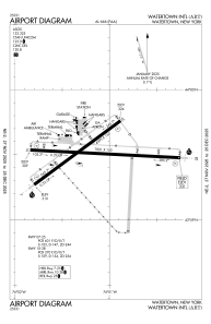
 ADC chart of KART
 Satellite view of KART

ADC chart of KART
Satellite view of KART
Sorry, we have no imagery here.
Sorry, we have no imagery here.
Sorry, we have no imagery here.
Sorry, we have no imagery here.
Sorry, we have no imagery here.
Sorry, we have no imagery here.


KART - Watertown Intl
Located in Watertown, United States
ICAO - ART, IATA - ART
Data provided by AirmateGeneral information
Coordinates: N43°59'31" W76°1'10"
Elevation is 330 feet MSL.
Magnetic variation is -12° East View others Airports in New York
Operational data
Special qualification required
Current time UTC: 09:44:06
Current local time:
Weather
METAR: KART 240856Z AUTO 00000KT 10SM -RA BKN041 OVC050 08/07 A2986 RMK AO2 SLP113 P0001 60003 T00780067 53007
TAF: KART 240902Z 2409/2506 VRB03KT 6SM -RA BR OVC040 FM241500 29006KT P6SM VCSH OVC015 FM241800 26008KT 6SM -SHRA OVC025 FM250200 26004KT P6SM BKN025
Communications frequencies: [VIEW]
Runways:
| RWY identifier | QFU | Length (ft) | Width (ft) | Surface | LDA (ft) |
| 07 | 53° | 4999 | 150 | ASPH | 4784 |
| 25 | 233° | 4999 | 150 | ASPH | 4999 |
| 10 | 93° | 7001 | 150 | ASPH | 7001 |
| 28 | 273° | 7001 | 150 | ASPH | 7001 |
Airport contact information
Address: Watertown United States
