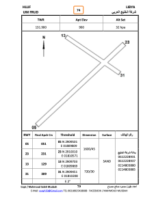
ADC chart of HLUF
 Satellite view of HLUF
Satellite view of HLUF
Sorry, we have no imagery here.
Sorry, we have no imagery here.
Sorry, we have no imagery here.
Sorry, we have no imagery here.
Sorry, we have no imagery here.
Sorry, we have no imagery here.


HLUF - Um-Farud
Located in , Libyan Arab Jamahiriya
ICAO - , IATA -
Data provided by AirmateGeneral information
Coordinates: N29°11'0" E18°11'0"
Elevation is 900 feet MSL.
View others Airports in Surt District
Operational data
Special qualification required
Current time UTC: 03:27:34
Current local time:
Weather at : - ( 0 km )
METAR: KGUL 070325Z AUTO 15008KT 9SM CLR 21/13 A3000 RMK A01
Communications frequencies: [VIEW]
Runways:
| RWY identifier | QFU | Length (ft) | Width (ft) | Surface | LDA (ft) |
| 05 | 0° | 0 | 0 | UNK | |
| 23 | 0° | 0 | 0 | UNK | |
| 13 | 0° | 0 | 0 | UNK | |
| 21 | 0° | 0 | 0 | UNK |
Airport contact information
Address: Libyan Arab Jamahiriya
Satellite view of HLUF
Sorry, we have no imagery here.
Sorry, we have no imagery here.
Sorry, we have no imagery here.
Sorry, we have no imagery here.
Sorry, we have no imagery here.
Sorry, we have no imagery here.