ADC chart of HLTG
 Satellite view of HLTG
Satellite view of HLTG
Sorry, we have no imagery here.
Sorry, we have no imagery here.
Sorry, we have no imagery here.
Sorry, we have no imagery here.
Sorry, we have no imagery here.
Sorry, we have no imagery here.


HLTG - Tagrift - V10
Located in , Libyan Arab Jamahiriya
ICAO - , IATA -
Data provided by AirmateGeneral information
Coordinates: N29°21'41" E18°0'26"
Elevation is 998 feet MSL.
Magnetic variation is 3° East View others Airports in Surt District
Operational data
Special qualification required
Current time UTC: 03:22:01
Current local time:
Weather at : - ( 0 km )
METAR: ULAA 070318Z 33001MPS 6000 -SHSN OVC006CB M02/M03 Q0993 R26/590538 NOSIG RMK QBB180 QFE743/0991
Communications frequencies: [VIEW]
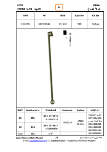
Runways:
| RWY identifier | QFU | Length (ft) | Width (ft) | Surface | LDA (ft) |
| 18 | 178° | 5368 | 103 | SAND | |
| 36 | 358° | 5368 | 103 | SAND |
Airport contact information
Address: Libyan Arab Jamahiriya
Satellite view of HLTG
Sorry, we have no imagery here.
Sorry, we have no imagery here.
Sorry, we have no imagery here.
Sorry, we have no imagery here.
Sorry, we have no imagery here.
Sorry, we have no imagery here.