ADC chart of HLRF
 Satellite view of HLRF

Satellite view of HLRF
Sorry, we have no imagery here.
Sorry, we have no imagery here.
Sorry, we have no imagery here.
Sorry, we have no imagery here.
Sorry, we have no imagery here.
Sorry, we have no imagery here.


HLRF - Jaref
Located in الحي الصناعي, Libyan Arab Jamahiriya
ICAO - , IATA -
Data provided by AirmateGeneral information
Coordinates: N31°12'27" E16°25'23"
Elevation is 35 feet MSL.
Magnetic variation is 3° East View others Airports in Surt District
Operational data
Special qualification required
Current time UTC: 03:22:03
Current local time:
Weather at : - ( 0 km )
METAR: PKWA 070320Z AUTO 07015G21KT 10SM SCT024 SCT028 31/24 A2980 RMK AO2 T03050237
Communications frequencies: [VIEW]
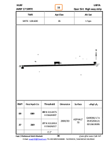
Runways:
| RWY identifier | QFU | Length (ft) | Width (ft) | Surface | LDA (ft) |
| 09 | 91° | 9144 | 77 | ASPH | |
| 27 | 271° | 9144 | 77 | ASPH |
Airport contact information
Address: الحي الصناعي Libyan Arab Jamahiriya
Satellite view of HLRF
Sorry, we have no imagery here.
Sorry, we have no imagery here.
Sorry, we have no imagery here.
Sorry, we have no imagery here.
Sorry, we have no imagery here.
Sorry, we have no imagery here.