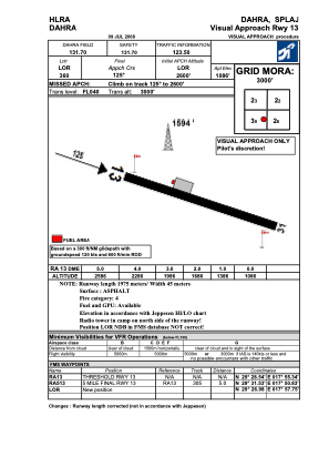
VAC chart of HLRA
 ADC chart of HLRA
 Satellite view of HLRA

ADC chart of HLRA
Satellite view of HLRA
Sorry, we have no imagery here.
Sorry, we have no imagery here.
Sorry, we have no imagery here.
Sorry, we have no imagery here.
Sorry, we have no imagery here.
Sorry, we have no imagery here.


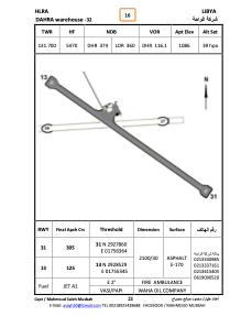
HLRA - Dahra Wh-32
Located in , Libyan Arab Jamahiriya
ICAO - HLRA, IATA -
Data provided by AirmateGeneral information
Coordinates: N29°28'16" E17°55'45"
Elevation is 1086 feet MSL.
Magnetic variation is 3° East View others Airports in Surt District
Operational data
Special qualification required
Current time UTC: 03:23:15
Current local time:
Weather at : - ( 0 km )
METAR: YCFS 070322Z AUTO 17024KT 1700 -GR SCT008 BKN010 BKN016 22/21 Q1012
Communications frequencies: [VIEW]
Runways:
| RWY identifier | QFU | Length (ft) | Width (ft) | Surface | LDA (ft) |
| 13 | 127° | 6860 | 109 | ASPH | |
| 31 | 307° | 6860 | 109 | ASPH | |
| 09 | 89° | 3582 | 96 | SAND | |
| 27 | 269° | 3582 | 96 | SAND |
Airport contact information
Address: Libyan Arab Jamahiriya
Satellite view of HLRA
Sorry, we have no imagery here.
Sorry, we have no imagery here.
Sorry, we have no imagery here.
Sorry, we have no imagery here.
Sorry, we have no imagery here.
Sorry, we have no imagery here.