IAC chart of HLGD
 ADC chart of HLGD
 Satellite view of HLGD

ADC chart of HLGD
Satellite view of HLGD
Sorry, we have no imagery here.
Sorry, we have no imagery here.
Sorry, we have no imagery here.
Sorry, we have no imagery here.
Sorry, we have no imagery here.
Sorry, we have no imagery here.


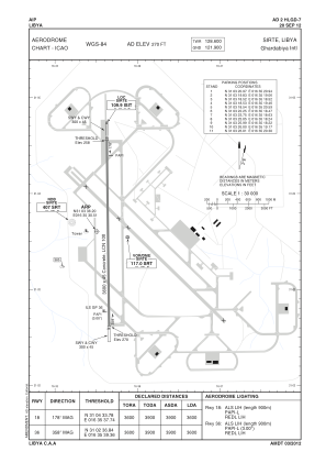
HLGD - Sirte / Ghardabiya International
Located in Sirte, Libyan Arab Jamahiriya
ICAO - HLGD, IATA - SRX
Data provided by AirmateGeneral information
Coordinates: N31°3'36" E16°35'31"
Elevation is 270 feet MSL.
Magnetic variation is 3° East View others Airports in Surt District
Operational data
Special qualification required
Current time UTC: 03:21:59
Current local time:
Weather at : - ( 0 km )
METAR: UWWW 070320Z 19003MPS 1900 R15/1900D SN OVC009 M01/M01 Q0998 R15/590240 NOSIG RMK QFE737/0983
Communications frequencies: [VIEW]
Runways:
| RWY identifier | QFU | Length (ft) | Width (ft) | Surface | LDA (ft) |
| 18 | 179° | 11818 | 141 | CONC | |
| 36 | 359° | 11818 | 141 | CONC | |
| 31 | 315° | 11773 | 145 | CONC | |
| 13 | 135° | 11773 | 145 | CONC |
Airport contact information
Address: Sirte Libyan Arab Jamahiriya
Satellite view of HLGD
Sorry, we have no imagery here.
Sorry, we have no imagery here.
Sorry, we have no imagery here.
Sorry, we have no imagery here.
Sorry, we have no imagery here.
Sorry, we have no imagery here.