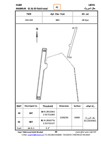
ADC chart of HLBR
 Satellite view of HLBR
Satellite view of HLBR
Sorry, we have no imagery here.
Sorry, we have no imagery here.
Sorry, we have no imagery here.
Sorry, we have no imagery here.
Sorry, we have no imagery here.
Sorry, we have no imagery here.


HLBR - Mabruk
Located in , Libyan Arab Jamahiriya
ICAO - , IATA -
Data provided by AirmateGeneral information
Coordinates: N29°51'34" E17°15'17"
Elevation is 800 feet MSL.
Magnetic variation is 3° East View others Airports in Surt District
Operational data
Special qualification required
Current time UTC: 03:28:53
Current local time:
Weather at : - ( 0 km )
METAR: CYPX 070326Z AUTO 04007KT 9SM SCT016 BKN024 M25/M27 A2978 RMK SLP089
Communications frequencies: [VIEW]
Runways:
| RWY identifier | QFU | Length (ft) | Width (ft) | Surface | LDA (ft) |
| 01 | 9° | 7457 | 254 | SAND | |
| 19 | 189° | 7457 | 254 | SAND |
Airport contact information
Address: Libyan Arab Jamahiriya
Satellite view of HLBR
Sorry, we have no imagery here.
Sorry, we have no imagery here.
Sorry, we have no imagery here.
Sorry, we have no imagery here.
Sorry, we have no imagery here.
Sorry, we have no imagery here.