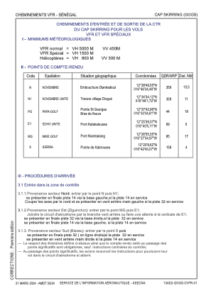
VAC chart of GOGS
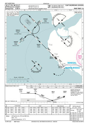
 IAC chart of GOGS
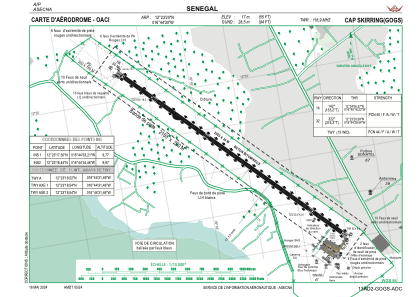
 ADC chart of GOGS
 Satellite view of GOGS

IAC chart of GOGSADC chart of GOGS
Satellite view of GOGS
Sorry, we have no imagery here.
Sorry, we have no imagery here.
Sorry, we have no imagery here.
Sorry, we have no imagery here.
Sorry, we have no imagery here.
Sorry, we have no imagery here.


GOGS - Aeroport International De Cap Skirring
Located in Cap Skirring, Senegal
ICAO - GOGS, IATA - CSK
Data provided by AirmateGeneral information
Coordinates: N12°23'20" W16°44'30"
Elevation is 56 feet MSL.
Magnetic variation is -7° East View others Airports in Ziguinchor
Operational data
Special qualification required
Current time UTC: 03:46:46
Current local time:
Weather
TAF: TAF GOGS 052300Z 0600/0624 34012KT CAVOK
Communications frequencies: [VIEW]
Runways:
| RWY identifier | QFU | Length (ft) | Width (ft) | Surface | LDA (ft) |
| 14 | 136° | 6562 | 98 | CONC | 6562 |
| 32 | 316° | 6562 | 98 | CONC | 6562 |
Airport contact information
Address: Cap Skirring Senegal
Satellite view of GOGS
Sorry, we have no imagery here.
Sorry, we have no imagery here.
Sorry, we have no imagery here.
Sorry, we have no imagery here.
Sorry, we have no imagery here.
Sorry, we have no imagery here.