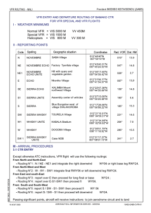
VAC chart of GABS
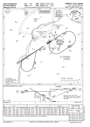
 IAC chart of GABS
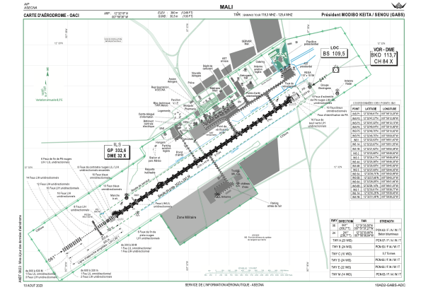
 ADC chart of GABS
 Satellite view of GABS

IAC chart of GABSADC chart of GABS
Satellite view of GABS
Sorry, we have no imagery here.
Sorry, we have no imagery here.
Sorry, we have no imagery here.
Sorry, we have no imagery here.
Sorry, we have no imagery here.
Sorry, we have no imagery here.


GABS - Aeroport International President Modibo Keita-Senou
Located in Bamako, Mali
ICAO - GABS, IATA - BKO
Data provided by AirmateGeneral information
Coordinates: N12°32'16" W7°56'35"
Elevation is 1247 feet MSL.
View others Airports in Koulikoro
Operational data
Special qualification required
Current time UTC: 20:59:37
Current local time:
Weather
METAR: GABS 222030Z 22005KT 9999 FEW020 31/24 Q1014 NOSIG
TAF: TAF GABS 221700Z 2218/2324 22010KT 9999 SCT020 PROB40 TEMPO 2221/2301 TS FEW020 FEW030CB PROB40 TEMPO 2316/2324 08015G35KT 3000 TSRA BLDU BKN020 FEW030CB
Communications frequencies: [VIEW]
Runways:
| RWY identifier | QFU | Length (ft) | Width (ft) | Surface | LDA (ft) |
| 06 | 57° | 10499 | 148 | ASP | |
| 24 | 237° | 10499 | 148 | ASP |
Airport contact information
Address: Bamako Mali
Satellite view of GABS
Sorry, we have no imagery here.
Sorry, we have no imagery here.
Sorry, we have no imagery here.
Sorry, we have no imagery here.
Sorry, we have no imagery here.
Sorry, we have no imagery here.