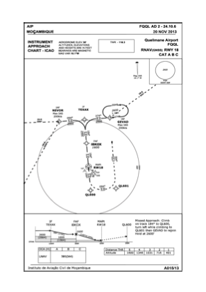
IAC chart of FQQL
 Satellite view of FQQL

Satellite view of FQQL
Sorry, we have no imagery here.
Sorry, we have no imagery here.
Sorry, we have no imagery here.
Sorry, we have no imagery here.
Sorry, we have no imagery here.
Sorry, we have no imagery here.


FQQL - Quelimane / National
Located in Quelimane, Mozambique
ICAO - FQQL, IATA - UEL
Data provided by AirmateGeneral information
Coordinates: S17°51'5" E36°52'6"
Elevation is 36 feet MSL.
View others Airports in Zambezia Province
Operational data
Special qualification required
Current time UTC: 08:29:01
Current local time:
Weather
METAR: FQQL 230800Z 15004KT 9999 BKN018 23/22 Q1024
TAF: TAF FQQL 230400Z 2306/2406 09010KT 9999 SCT020 TX27/2313Z TN22/2402Z FM231000 19015KT
Communications frequencies: [VIEW]
Runways:
| RWY identifier | QFU | Length (ft) | Width (ft) | Surface | LDA (ft) |
| 09 | 85° | 2980 | 98 | GVL | |
| 27 | 265° | 2980 | 98 | GVL | |
| 18 | 174° | 5906 | 148 | ASP | |
| 36 | 354° | 5906 | 148 | ASP |
Airport contact information
Address: Quelimane Mozambique
Satellite view of FQQL
Sorry, we have no imagery here.
Sorry, we have no imagery here.
Sorry, we have no imagery here.
Sorry, we have no imagery here.
Sorry, we have no imagery here.
Sorry, we have no imagery here.