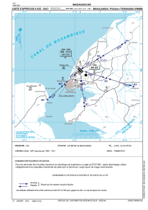
VAC chart of FMNM
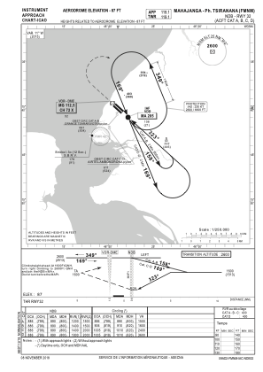
 IAC chart of FMNM
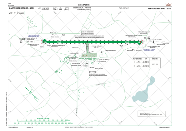
 ADC chart of FMNM
 Satellite view of FMNM

IAC chart of FMNMADC chart of FMNM
Satellite view of FMNM
Sorry, we have no imagery here.
Sorry, we have no imagery here.
Sorry, we have no imagery here.
Sorry, we have no imagery here.
Sorry, we have no imagery here.
Sorry, we have no imagery here.


FMNM - Mahajanga/Philibert Tsiranana
Located in Mahajanga, Madagascar
ICAO - FMNM, IATA - MJN
Data provided by AirmateGeneral information
Coordinates: S15°39'60" E46°21'4"
Elevation is 87 feet MSL.
View others Airports in Mahajanga
Operational data
Special qualification required
Current time UTC: 08:16:13
Current local time:
Weather
METAR: FMNM 220800Z 28007KT 9999 FEW023 32/21 Q1016 NOSIG
TAF: TAF FMNM 220500Z 2206/2306 12008KT 9999 FEW023 BECMG 2208/2210 32010KT BECMG 2218/2220 14006KT
Communications frequencies: [VIEW]
Runways:
| RWY identifier | QFU | Length (ft) | Width (ft) | Surface | LDA (ft) |
| 14 | 132° | 7218 | 148 | ASP | |
| 32 | 312° | 7218 | 148 | ASP |
Airport contact information
Address: Mahajanga Madagascar
Satellite view of FMNM
Sorry, we have no imagery here.
Sorry, we have no imagery here.
Sorry, we have no imagery here.
Sorry, we have no imagery here.
Sorry, we have no imagery here.
Sorry, we have no imagery here.