VAC chart of EIIF
 Satellite view of EIIF

Satellite view of EIIF
Sorry, we have no imagery here.
Sorry, we have no imagery here.
Sorry, we have no imagery here.
Sorry, we have no imagery here.
Sorry, we have no imagery here.
Sorry, we have no imagery here.


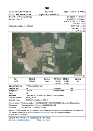
EIIF - Ilas Airfield
Located in 18.5Nm E Of Waterford City, Ireland
ICAO - , IATA -
Data provided by AirmateGeneral information
Coordinates: N52°17'44" W6°40'53"
Elevation is 140 feet MSL.
Magnetic variation is -2° East View others Airports in County Westmeath
Operational data
Special qualification required
Current time UTC: 03:42:31
Current local time:
Communications frequencies: [VIEW]
Runways:
| RWY identifier | QFU | Length (ft) | Width (ft) | Surface | LDA (ft) |
| 18 | 0° | 1969 | 49 | GRAS | 1772 |
| 36 | 0° | 1969 | 49 | GRAS | 1870 |
Airport contact information
Address: 18.5Nm E Of Waterford City Ireland
Web: https://ilas.ie/
Satellite view of EIIF
Sorry, we have no imagery here.
Sorry, we have no imagery here.
Sorry, we have no imagery here.
Sorry, we have no imagery here.
Sorry, we have no imagery here.
Sorry, we have no imagery here.