VAC chart of EBNE
 Satellite view of EBNE

Satellite view of EBNE
Sorry, we have no imagery here.
Sorry, we have no imagery here.
Sorry, we have no imagery here.
Sorry, we have no imagery here.
Sorry, we have no imagery here.
Sorry, we have no imagery here.


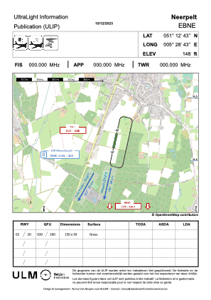
EBNE - Neerpelt
Located in Neerpelt, Belgium
ICAO - EBNE, IATA -
Data provided by AirmateGeneral information
Coordinates: N51°12'43" E5°28'43"
Elevation is 140 feet MSL.
Magnetic variation is 2° East View others Airports in Limburg
Operational data
Special qualification required
Current time UTC: 02:18:53
Current local time:
Weather at : EBBL - Kleine-Brogel ( 5 km )
TAF: TAF EBBL 231541Z 2319/2407 31010G22KT 9999 FEW060 BECMG 2319/2320 27005G15KT BECMG 2405/2407 21008KT 8000 SCT280
Communications frequencies: [VIEW]
Runways:
Airport contact information
Address: Neerpelt Belgium
Satellite view of EBNE
Sorry, we have no imagery here.
Sorry, we have no imagery here.
Sorry, we have no imagery here.
Sorry, we have no imagery here.
Sorry, we have no imagery here.
Sorry, we have no imagery here.