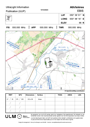
VAC chart of EBIS
 Satellite view of EBIS
Satellite view of EBIS
Sorry, we have no imagery here.
Sorry, we have no imagery here.
Sorry, we have no imagery here.
Sorry, we have no imagery here.
Sorry, we have no imagery here.
Sorry, we have no imagery here.


EBIS - Ath / Isieres
Located in Ath, Belgium
ICAO - EBIS, IATA -
Data provided by AirmateGeneral information
Coordinates: N50°39'51" E3°48'16"
Elevation is 90 feet MSL.
Magnetic variation is 1° East View others Airports in Hainaut
Operational data
Special qualification required
Current time UTC: 06:54:20
Current local time:
Weather at : EBCV - Chievres ( 10 km )
METAR: EBCV 210647Z AUTO VRB02KT 4900 BR BKN003/// BKN090/// 10/09 Q1016 YLO
TAF: TAF EBCV 210541Z 2107/2116 29003KT 9999 FEW050 SCT140 BKN200 BECMG 2108/2110 32008KT PROB40 TEMPO 2114/2116 5000 -SHRA SCT035TCU BKN110 BY EBWM
Communications frequencies: [VIEW]
Runways:
| RWY identifier | QFU | Length (ft) | Width (ft) | Surface | LDA (ft) |
| 17 | 0° | 495 | 164 | GRASS | |
| 35 | 0° | 495 | 164 | GRASS |
Airport contact information
Address: Ath Belgium
Satellite view of EBIS
Sorry, we have no imagery here.
Sorry, we have no imagery here.
Sorry, we have no imagery here.
Sorry, we have no imagery here.
Sorry, we have no imagery here.
Sorry, we have no imagery here.