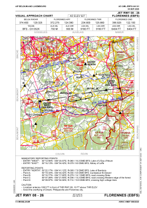
VAC chart of EBFS
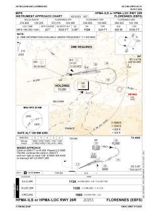
 IAC chart of EBFS
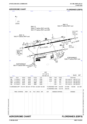
 ADC chart of EBFS
 Satellite view of EBFS
IAC chart of EBFSADC chart of EBFS
Satellite view of EBFS
Sorry, we have no imagery here.
Sorry, we have no imagery here.
Sorry, we have no imagery here.
Sorry, we have no imagery here.
Sorry, we have no imagery here.
Sorry, we have no imagery here.


EBFS - Florennes
Located in Florennes, Belgium
ICAO - EBFS, IATA -
Data provided by AirmateGeneral information
Coordinates: N50°14'36" E4°38'45"
Elevation is 927 feet MSL.
Magnetic variation is 2° East View others Airports in Namur
Operational data
Special qualification required
Current time UTC: 21:56:34
Current local time:
Weather
METAR: EBFS 182125Z AUTO 11009KT 9999 NCD M01/M07 Q1020 BLU
TAF: TAF EBFS 181541Z 1819/1907 12010KT 9999 FEW180 SCT280
Communications frequencies: [VIEW]
Runways:
| RWY identifier | QFU | Length (ft) | Width (ft) | Surface | LDA (ft) |
| 08L | 80° | 11115 | 148 | ASPH | 8648 |
| 26R | 260° | 11115 | 148 | ASPH | 8763 |
| 08R | 80° | 7375 | 75 | ASPH | 5965 |
| 26L | 260° | 7375 | 75 | ASPH | 6027 |
Airport contact information
Address: Florennes Belgium
Other aviation service providers
Aviation club (not for profit)

Royal Belgian Defence Aeroclub
Royal Belgian Defence Aeroclub
comopsair-avia-secretariaat@mil.be+3224419073