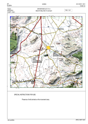
VAC chart of DAOV
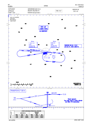
 IAC chart of DAOV
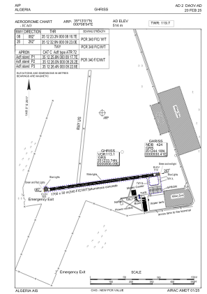
 ADC chart of DAOV
 Satellite view of DAOV

IAC chart of DAOVADC chart of DAOV
Satellite view of DAOV
Sorry, we have no imagery here.
Sorry, we have no imagery here.
Sorry, we have no imagery here.
Sorry, we have no imagery here.
Sorry, we have no imagery here.
Sorry, we have no imagery here.


DAOV - Ghriss
Located in Ghriss, Algeria
ICAO - DAOV, IATA - MUW
Data provided by AirmateGeneral information
Coordinates: N35°13'1" E0°8'54"
Elevation is 1686 feet MSL.
View others Airports in Mascara Province
Operational data
Special qualification required
Current time UTC: 00:42:24
Current local time:
Weather
METAR: DAOV 230000Z 21003KT CAVOK 16/08 Q1015
TAF: TAF DAOV 222300Z 2300/2309 VRB02KT CAVOK BECMG 2303/2306 22010KT
Communications frequencies: [VIEW]
Runways:
| RWY identifier | QFU | Length (ft) | Width (ft) | Surface | LDA (ft) |
| 08 | 82° | 5577 | 98 | ASP | |
| 26 | 262° | 5577 | 98 | ASP |
Airport contact information
Address: Ghriss Algeria
Satellite view of DAOV
Sorry, we have no imagery here.
Sorry, we have no imagery here.
Sorry, we have no imagery here.
Sorry, we have no imagery here.
Sorry, we have no imagery here.
Sorry, we have no imagery here.