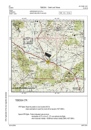
VAC chart of DABS
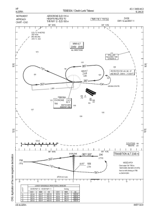
 IAC chart of DABS
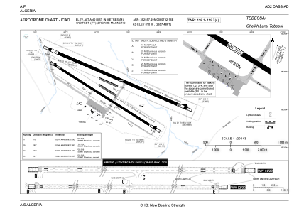
 ADC chart of DABS
 Satellite view of DABS

IAC chart of DABSADC chart of DABS
Satellite view of DABS
Sorry, we have no imagery here.
Sorry, we have no imagery here.
Sorry, we have no imagery here.
Sorry, we have no imagery here.
Sorry, we have no imagery here.
Sorry, we have no imagery here.


DABS - Tebessa / Cheikh Larbi Tebessi
Located in Tebessa, Algeria
ICAO - DABS, IATA - TEE
Data provided by AirmateGeneral information
Coordinates: N35°25'57" E8°7'32"
Elevation is 2657 feet MSL.
Magnetic variation is 3° East View others Airports in Tébessa Province
Operational data
Special qualification required
Current time UTC: 10:26:34
Current local time:
Weather
METAR: DABS 211000Z 24003KT 9999 FEW033 SCT200 22/11 Q1021
TAF: TAF COR DABS 210500Z 2106/2206 29008KT 9999 FEW023 SCT090 TEMPO 2112/2119 FEW030CB
Communications frequencies: [VIEW]
Runways:
| RWY identifier | QFU | Length (ft) | Width (ft) | Surface | LDA (ft) |
| 11 | 113° | 9843 | 148 | ASP | |
| 29 | 293° | 9843 | 148 | ASP | |
| 12 | 124° | 7874 | 98 | ASP | |
| 30 | 304° | 7874 | 98 | ASP |
Airport contact information
Address: Tebessa Algeria
Satellite view of DABS
Sorry, we have no imagery here.
Sorry, we have no imagery here.
Sorry, we have no imagery here.
Sorry, we have no imagery here.
Sorry, we have no imagery here.
Sorry, we have no imagery here.