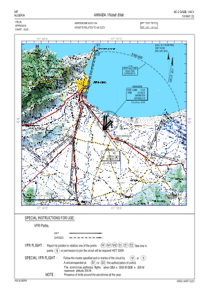
VAC chart of DABB
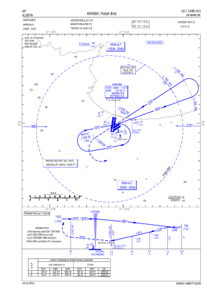
 IAC chart of DABB
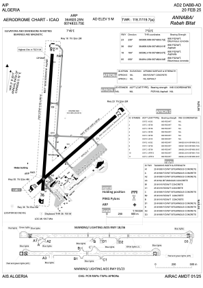
 ADC chart of DABB
 Satellite view of DABB

IAC chart of DABBADC chart of DABB
Satellite view of DABB
Sorry, we have no imagery here.
Sorry, we have no imagery here.
Sorry, we have no imagery here.
Sorry, we have no imagery here.
Sorry, we have no imagery here.
Sorry, we have no imagery here.


DABB - Annaba / Rabah Bitat
Located in Annaba, Algeria
ICAO - DABB, IATA - AAE
Data provided by AirmateGeneral information
Coordinates: N36°49'20" E7°48'34"
Elevation is 16 feet MSL.
Magnetic variation is 3° East View others Airports in El Tarf Province
Operational data
Special qualification required
Current time UTC: 19:56:59
Current local time:
Weather
METAR: DABB 251900Z 01009KT CAVOK 19/15 Q1021
TAF: TAF DABB 251700Z 2518/2618 01012KT 9999 FEW020 BECMG 2519/2521 VRB02KT PROB30 2600/2608 3000 BR BKN010
Communications frequencies: [VIEW]
Runways:
| RWY identifier | QFU | Length (ft) | Width (ft) | Surface | LDA (ft) |
| 05 | 52° | 7513 | 148 | ASP | |
| 23 | 232° | 7513 | 148 | ASP | |
| 18 | 186° | 9843 | 148 | UNK | |
| 36 | 6° | 9843 | 148 | UNK |
Airport contact information
Address: Annaba Algeria
Satellite view of DABB
Sorry, we have no imagery here.
Sorry, we have no imagery here.
Sorry, we have no imagery here.
Sorry, we have no imagery here.
Sorry, we have no imagery here.
Sorry, we have no imagery here.