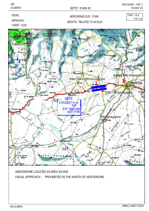
VAC chart of DAAS
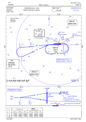
 IAC chart of DAAS
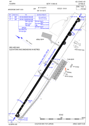
 ADC chart of DAAS
 Satellite view of DAAS
IAC chart of DAASADC chart of DAAS
Satellite view of DAAS
Sorry, we have no imagery here.
Sorry, we have no imagery here.
Sorry, we have no imagery here.
Sorry, we have no imagery here.
Sorry, we have no imagery here.
Sorry, we have no imagery here.


DAAS - Setif / 8 Mai 45
Located in Setif, Algeria
ICAO - DAAS, IATA - QSF
Data provided by AirmateGeneral information
Coordinates: N36°10'43" E5°19'48"
Elevation is 3333 feet MSL.
View others Airports in Sétif Province
Operational data
Special qualification required
Current time UTC: 23:10:24
Current local time:
Weather
METAR: DAAS 192200Z 12005KT 8000 FEW026CB SCT030 22/06 Q1021
TAF: TAF DAAS 191700Z 1918/2018 22008KT CAVOK PROB30 TEMPO 1918/1922 FEW023TCU
Communications frequencies: [VIEW]
Runways:
| RWY identifier | QFU | Length (ft) | Width (ft) | Surface | LDA (ft) |
| 09 | 87° | 9514 | 148 | UNK | |
| 27 | 267° | 9514 | 148 | UNK |
Airport contact information
Address: Setif Algeria
Satellite view of DAAS
Sorry, we have no imagery here.
Sorry, we have no imagery here.
Sorry, we have no imagery here.
Sorry, we have no imagery here.
Sorry, we have no imagery here.
Sorry, we have no imagery here.