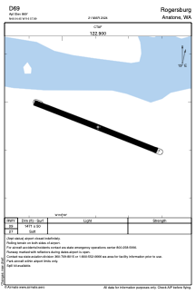
ADC chart of D69
 Satellite view of D69

Satellite view of D69
Sorry, we have no imagery here.
Sorry, we have no imagery here.
Sorry, we have no imagery here.
Sorry, we have no imagery here.
Sorry, we have no imagery here.
Sorry, we have no imagery here.


D69 - Rogersburg
Located in Anatone, United States
ICAO - D69, IATA -
Data provided by AirmateGeneral information
Coordinates: N46°4'27" W116°57'54"
Elevation is 869 feet MSL.
View others Airports in Washington
Operational data
Special qualification required
Current time UTC: 13:15:31
Current local time:
Weather at : KLWS - Lewiston/Nez Perce County ( 34 km )
METAR: KLWS 291256Z 00000KT 10SM CLR 17/09 A2987 RMK AO2 SLP104 T01720094 $
TAF: KLWS 291120Z 2912/3012 VRB06KT P6SM FEW050 SCT130 FM291900 30011G24KT P6SM BKN070 PROB30 2919/2923 -SHRA BKN050 FM292300 30015G25KT P6SM SCT070 BKN100 FM300300 26008KT P6SM FEW090
Communications frequencies: [VIEW]
Runways:
| RWY identifier | QFU | Length (ft) | Width (ft) | Surface | LDA (ft) |
| 09 | 112° | 1471 | 50 | GRASS | |
| 27 | 292° | 1471 | 50 | GRASS |
Airport contact information
Address: Anatone United States
Satellite view of D69
Sorry, we have no imagery here.
Sorry, we have no imagery here.
Sorry, we have no imagery here.
Sorry, we have no imagery here.
Sorry, we have no imagery here.
Sorry, we have no imagery here.