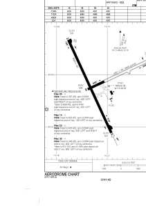
ADC chart of CYHY
 Satellite view of CYHY

Satellite view of CYHY
Sorry, we have no imagery here.
Sorry, we have no imagery here.
Sorry, we have no imagery here.
Sorry, we have no imagery here.
Sorry, we have no imagery here.
Sorry, we have no imagery here.


CYHY - Merlyn Carter Airport
Located in Hay River, Canada
ICAO - CYHY, IATA - YHY
Data provided by AirmateGeneral information
Coordinates: N60°50'23" W115°46'58"
Elevation is 541 feet MSL.
Magnetic variation is 16.0756° East View others Airports in Northwest Territories
Operational data
Special qualification required
Current time UTC: 05:59:34
Current local time:
Weather
METAR: CYHY 250500Z 15005KT 15SM FEW120 OVC180 18/05 A2979 RMK AC2AC6 SLP092 DENSITY ALT 1200FT
TAF: TAF CYHY 250540Z 2506/2518 17005KT P6SM SCT100 BKN200 FM251200 17008KT P6SM BKN080 BECMG 2516/2518 09008KT RMK NXT FCST BY 251200Z
Communications frequencies: [VIEW]
Runways:
| RWY identifier | QFU | Length (ft) | Width (ft) | Surface | LDA (ft) |
| 05 | 65° | 4001 | 150 | GRAVE | 4001 |
| 23 | 245° | 4001 | 150 | GRAVE | 4001 |
| 14 | 155° | 6000 | 150 | ASPH | 6000 |
| 32 | 335° | 6000 | 150 | ASPH | 6000 |
Airport contact information
Address: Hay River Canada
Satellite view of CYHY
Sorry, we have no imagery here.
Sorry, we have no imagery here.
Sorry, we have no imagery here.
Sorry, we have no imagery here.
Sorry, we have no imagery here.
Sorry, we have no imagery here.