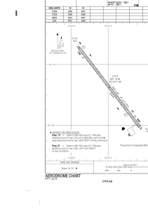
ADC chart of CYFR
 Satellite view of CYFR
Satellite view of CYFR
Sorry, we have no imagery here.
Sorry, we have no imagery here.
Sorry, we have no imagery here.
Sorry, we have no imagery here.
Sorry, we have no imagery here.
Sorry, we have no imagery here.


CYFR - Fort Resolution
Located in , Canada
ICAO - CYFR, IATA - YFR
Data provided by AirmateGeneral information
Coordinates: N61°10'51" W113°41'23"
Elevation is 527 feet MSL.
Magnetic variation is 16.6308° East View others Airports in Northwest Territories
Operational data
Special qualification required
Current time UTC: 17:48:51
Current local time:
Weather
METAR: CYFR 231700Z 16004KT 15SM FEW090 15/09 A2994 RMK AC1 AC TR SLP148
Communications frequencies: [VIEW]
Runways:
| RWY identifier | QFU | Length (ft) | Width (ft) | Surface | LDA (ft) |
| 13 | 142° | 4001 | 98 | GRAVE | 4001 |
| 31 | 322° | 4001 | 98 | GRAVE | 3346 |
Airport contact information
Address: Canada
Satellite view of CYFR
Sorry, we have no imagery here.
Sorry, we have no imagery here.
Sorry, we have no imagery here.
Sorry, we have no imagery here.
Sorry, we have no imagery here.
Sorry, we have no imagery here.