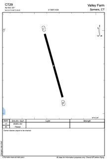
ADC chart of CT29
 Satellite view of CT29

Satellite view of CT29
Sorry, we have no imagery here.
Sorry, we have no imagery here.
Sorry, we have no imagery here.
Sorry, we have no imagery here.
Sorry, we have no imagery here.
Sorry, we have no imagery here.


CT29 - Valley Farm
Located in Somers, United States
ICAO - CT29, IATA -
Data provided by AirmateGeneral information
Coordinates: N42°0'47" W72°28'21"
Elevation is 221 feet MSL.
View others Airports in Connecticut
Operational data
Special qualification required
Current time UTC: 16:58:22
Current local time:
Weather at : KBDL - Bradley Intl ( 19 km )
METAR: KBDL 231651Z VRB04KT 10SM OVC025 11/06 A2979 RMK AO2 SLP088 VCSH SE-NW T01110061
TAF: KBDL 231458Z 2315/2418 VRB03KT P6SM BKN025 FM231700 24005KT P6SM BKN025 PROB30 2318/2322 4SM -SHRA OVC015 FM232200 26005KT P6SM OVC020 FM240900 24004KT P6SM BKN030
Communications frequencies: [VIEW]
Runways:
| RWY identifier | QFU | Length (ft) | Width (ft) | Surface | LDA (ft) |
| 17 | 0° | 2538 | 50 | ASPH | |
| 35 | 0° | 2538 | 50 | ASPH |
Airport contact information
Address: Somers United States
Satellite view of CT29
Sorry, we have no imagery here.
Sorry, we have no imagery here.
Sorry, we have no imagery here.
Sorry, we have no imagery here.
Sorry, we have no imagery here.
Sorry, we have no imagery here.