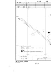
ADC chart of CET9
 Satellite view of CET9

Satellite view of CET9
Sorry, we have no imagery here.
Sorry, we have no imagery here.
Sorry, we have no imagery here.
Sorry, we have no imagery here.
Sorry, we have no imagery here.
Sorry, we have no imagery here.


CET9 - Jean Marie River
Located in Jean Marie River, Canada
ICAO - CET9, IATA -
Data provided by AirmateGeneral information
Coordinates: N61°31'21" W120°37'30"
Elevation is 457 feet MSL.
Magnetic variation is 19.3500° East View others Airports in Northwest Territories
Operational data
Special qualification required
Current time UTC: 07:31:53
Current local time:
Weather at : CYFS - Fort Simpson ( 42 km )
TAF: TAF CYFS 210540Z 2106/2118 VRB03KT P6SM SCT070 BKN150 BKN250 TEMPO 2106/2110 P6SM -SHRA BKN070 FM211000 VRB03KT P6SM BKN030 TEMPO 2110/2117 5SM -SHRA BR BKN020 FM211700 18008KT P6SM BKN040 RMK NXT FCST BY 211200Z
Communications frequencies: [VIEW]
Runways:
| RWY identifier | QFU | Length (ft) | Width (ft) | Surface | LDA (ft) |
| 11 | 130° | 2512 | 59 | GRAVE | 2512 |
| 29 | 310° | 2512 | 59 | GRAVE | 2512 |
Airport contact information
Address: Jean Marie River Canada
Satellite view of CET9
Sorry, we have no imagery here.
Sorry, we have no imagery here.
Sorry, we have no imagery here.
Sorry, we have no imagery here.
Sorry, we have no imagery here.
Sorry, we have no imagery here.