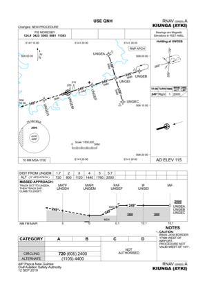
IAC chart of AYKI
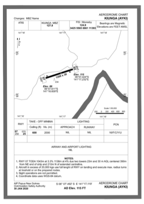
 ADC chart of AYKI
 Satellite view of AYKI

ADC chart of AYKI
Satellite view of AYKI
Sorry, we have no imagery here.
Sorry, we have no imagery here.
Sorry, we have no imagery here.
Sorry, we have no imagery here.
Sorry, we have no imagery here.
Sorry, we have no imagery here.


AYKI - Kiunga
Located in , Papua New Guinea
ICAO - AYKI, IATA - UNG
Data provided by AirmateGeneral information
Coordinates: S6°7'29" E141°17'6"
Elevation is 102 feet MSL.
View others Airports in Western (Fly River)
Operational data
Special qualification required
Current time UTC: 21:42:38
Current local time:
Weather at : - ( 0 km )
METAR: PASD 282138Z 02005KT 10SM FEW018 SCT035 SCT050 08/04 A2945 RMK AO2 $
Communications frequencies: [VIEW]
Runways:
| RWY identifier | QFU | Length (ft) | Width (ft) | Surface | LDA (ft) |
| 07 | 0° | 3937 | 75 | UNK | |
| 25 | 0° | 3937 | 75 | UNK |
Airport contact information
Address: Papua New Guinea
Satellite view of AYKI
Sorry, we have no imagery here.
Sorry, we have no imagery here.
Sorry, we have no imagery here.
Sorry, we have no imagery here.
Sorry, we have no imagery here.
Sorry, we have no imagery here.