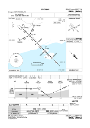
IAC chart of AYDU
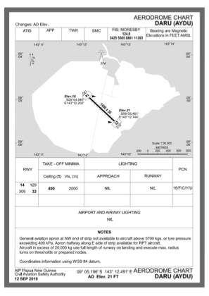
 ADC chart of AYDU
 Satellite view of AYDU

ADC chart of AYDU
Satellite view of AYDU
Sorry, we have no imagery here.
Sorry, we have no imagery here.
Sorry, we have no imagery here.
Sorry, we have no imagery here.
Sorry, we have no imagery here.
Sorry, we have no imagery here.


AYDU - Daru
Located in , Papua New Guinea
ICAO - AYDU, IATA - DAU
Data provided by AirmateGeneral information
Coordinates: S9°5'12" E143°12'29"
Elevation is 14 feet MSL.
View others Airports in Western (Fly River)
Operational data
Special qualification required
Current time UTC: 13:05:27
Current local time:
Weather at : - ( 0 km )
METAR: CYZE 291302Z AUTO 21005KT 180V240 9SM BKN012 BKN091 14/12 A2995 RMK SLP146
Communications frequencies: [VIEW]
Runways:
| RWY identifier | QFU | Length (ft) | Width (ft) | Surface | LDA (ft) |
| 14 | 135° | 4593 | 98 | ASP | |
| 32 | 315° | 4593 | 98 | ASP |
Airport contact information
Address: Papua New Guinea
Satellite view of AYDU
Sorry, we have no imagery here.
Sorry, we have no imagery here.
Sorry, we have no imagery here.
Sorry, we have no imagery here.
Sorry, we have no imagery here.
Sorry, we have no imagery here.