ADC chart of A34
 Satellite view of A34

Satellite view of A34
Sorry, we have no imagery here.
Sorry, we have no imagery here.
Sorry, we have no imagery here.
Sorry, we have no imagery here.
Sorry, we have no imagery here.
Sorry, we have no imagery here.


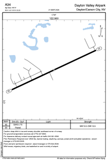
A34 - Dayton Valley Airpark
Located in Dayton/Carson City, United States
ICAO - A34, IATA -
Data provided by AirmateGeneral information
Coordinates: N39°14'18" W119°33'20"
Elevation is 4414 feet MSL.
Magnetic variation is 16° East View others Airports in Nevada
Operational data
Special qualification required
Current time UTC: 15:31:13
Current local time:
Weather at : KCXP - Carson City ( 16 km )
METAR: KCXP 301515Z AUTO 00000KT 10SM CLR 20/03 A3030 RMK AO2
TAF: KCXP 301120Z 3012/3112 VRB05KT P6SM SKC FM302300 04007KT P6SM SKC FM310000 30009KT P6SM SKC FM310400 VRB03KT P6SM SKC
Communications frequencies: [VIEW]
Runways:
| RWY identifier | QFU | Length (ft) | Width (ft) | Surface | LDA (ft) |
| 05 | 65° | 5343 | 75 | ASPH | |
| 23 | 245° | 5343 | 75 | ASPH |
Airport contact information
Address: Dayton/Carson City United States
Satellite view of A34
Sorry, we have no imagery here.
Sorry, we have no imagery here.
Sorry, we have no imagery here.
Sorry, we have no imagery here.
Sorry, we have no imagery here.
Sorry, we have no imagery here.