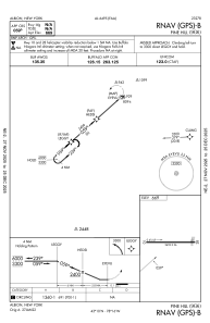
IAC chart of 9G6
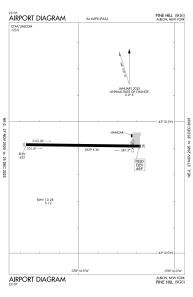
 ADC chart of 9G6
 Satellite view of 9G6

ADC chart of 9G6
Satellite view of 9G6
Sorry, we have no imagery here.
Sorry, we have no imagery here.
Sorry, we have no imagery here.
Sorry, we have no imagery here.
Sorry, we have no imagery here.
Sorry, we have no imagery here.


9G6 - Pine Hill
Located in Albion, United States
ICAO - 9G6, IATA -
Data provided by AirmateGeneral information
Coordinates: N43°10'25" W78°16'29"
Elevation is 669 feet MSL.
Magnetic variation is -11° East View others Airports in New York
Operational data
Special qualification required
Current time UTC: 18:19:45
Current local time:
Weather at : KGVQ - Genesee County ( 18 km )
METAR: KGVQ 211756Z AUTO 11011G17KT 10SM -RA OVC009 11/09 A2977 RMK AO2 CIG 007V013 SLP083 6//// T01060094 10106 20083 58010 PNO $
Communications frequencies: [VIEW]
Runways:
| RWY identifier | QFU | Length (ft) | Width (ft) | Surface | LDA (ft) |
| 10 | 91° | 2659 | 36 | ASPH | |
| 28 | 271° | 2659 | 36 | ASPH |
Airport contact information
Address: Albion United States
Satellite view of 9G6
Sorry, we have no imagery here.
Sorry, we have no imagery here.
Sorry, we have no imagery here.
Sorry, we have no imagery here.
Sorry, we have no imagery here.
Sorry, we have no imagery here.