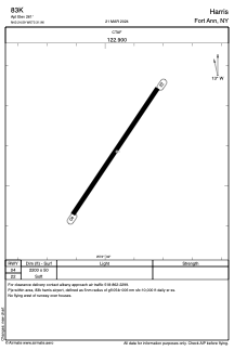
ADC chart of 83K
 Satellite view of 83K

Satellite view of 83K
Sorry, we have no imagery here.
Sorry, we have no imagery here.
Sorry, we have no imagery here.
Sorry, we have no imagery here.
Sorry, we have no imagery here.
Sorry, we have no imagery here.


83K - Harris
Located in Fort Ann, United States
ICAO - 83K, IATA -
Data provided by AirmateGeneral information
Coordinates: N43°24'35" W73°31'58"
Elevation is 261 feet MSL.
View others Airports in New York
Operational data
Special qualification required
Current time UTC: 20:11:57
Current local time:
Communications frequencies: [VIEW]
Runways:
| RWY identifier | QFU | Length (ft) | Width (ft) | Surface | LDA (ft) |
| 04 | 34° | 2200 | 50 | GRASS | |
| 22 | 214° | 2200 | 50 | GRASS |
Airport contact information
Address: Fort Ann United States
Satellite view of 83K
Sorry, we have no imagery here.
Sorry, we have no imagery here.
Sorry, we have no imagery here.
Sorry, we have no imagery here.
Sorry, we have no imagery here.
Sorry, we have no imagery here.