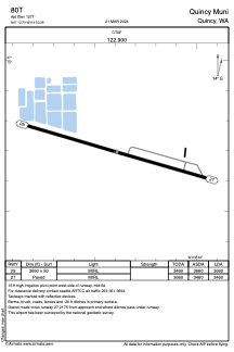
ADC chart of 80T
 Satellite view of 80T
Satellite view of 80T
Sorry, we have no imagery here.
Sorry, we have no imagery here.
Sorry, we have no imagery here.
Sorry, we have no imagery here.
Sorry, we have no imagery here.
Sorry, we have no imagery here.


80T - Quincy Muni
Located in Quincy, United States
ICAO - 80T, IATA -
Data provided by AirmateGeneral information
Coordinates: N47°12'42" W119°50'23"
Elevation is 1271 feet MSL.
Magnetic variation is 20° East View others Airports in Washington
Operational data
Special qualification required
Current time UTC: 17:19:56
Current local time:
Weather at : KEPH - Ephrata Muni ( 27 km )
METAR: KEPH 271653Z AUTO 03004KT 10SM CLR 19/00 A3020 RMK AO2 SLP222 T01940000
Communications frequencies: [VIEW]
Runways:
| RWY identifier | QFU | Length (ft) | Width (ft) | Surface | LDA (ft) |
| 09 | 106° | 3660 | 50 | ASPH | 3660 |
| 27 | 286° | 3660 | 50 | ASPH | 3460 |
Airport contact information
Address: Quincy United States
Satellite view of 80T
Sorry, we have no imagery here.
Sorry, we have no imagery here.
Sorry, we have no imagery here.
Sorry, we have no imagery here.
Sorry, we have no imagery here.
Sorry, we have no imagery here.