ADC chart of 7B9
 Satellite view of 7B9

Satellite view of 7B9
Sorry, we have no imagery here.
Sorry, we have no imagery here.
Sorry, we have no imagery here.
Sorry, we have no imagery here.
Sorry, we have no imagery here.
Sorry, we have no imagery here.


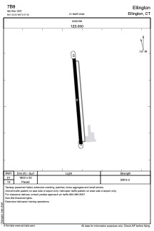
7B9 - Ellington
Located in Ellington, United States
ICAO - 7B9, IATA -
Data provided by AirmateGeneral information
Coordinates: N41°55'32" W72°27'26"
Elevation is 253 feet MSL.
Magnetic variation is -15° East View others Airports in Connecticut
Operational data
Special qualification required
Current time UTC: 15:42:10
Current local time:
Weather at : KBDL - Bradley Intl ( 19 km )
METAR: KBDL 201451Z 33011G17KT 10SM BKN041 14/04 A2992 RMK AO2 SLP132 T01440039 53001
TAF: KBDL 201442Z 2015/2118 34011G20KT P6SM SCT045 FM201800 36008KT P6SM SCT040 FM202200 04005KT P6SM OVC030 FM210200 03005KT P6SM -DZ OVC030
Communications frequencies: [VIEW]
Runways:
| RWY identifier | QFU | Length (ft) | Width (ft) | Surface | LDA (ft) |
| 01 | 355° | 1800 | 50 | ASPH | |
| 19 | 175° | 1800 | 50 | ASPH |
Airport contact information
Address: Ellington United States
Other aviation service providers
Flight schools

Northeast Helicopters Flight Services, Llc
Northeast Helicopters Flight Services, Llc
john@northeasthelicopters.com8608712054